Written by Simon Ngo, Senior Local Guide
Vietnam Discovery Tours · Hanoi-based · Since 2016
Our editorial team is made up of local travel specialists who have lived in and explored Vietnam for over a decade. Every guide is based on on-the-ground visits, verified GPS data, and first-hand experience.
Questions about this guide? Chat with us on WhatsApp ↗
A City That Woke Up Bigger
On July 1, 2025, I stood on the Dragon Bridge at midnight and watched fireworks light up a river that now belonged to a much larger story. By dawn, Da Nang had absorbed Quảng Nam Province — and with it, 1.9 million more people, 10,574 km² of land, and two UNESCO World Heritage Sites that had always felt like cousins we visited on weekends. As of that morning, they were home. This **Da Nang Tourist Map 2026** captures that new reality — 52 verified attractions with GPS coordinates across 8 zones, from Hai Van Pass in the north to Hội An Ancient Town in the south.

The numbers tell the scale: Greater Da Nang now covers 11,860 km², houses 3.07 million residents, and stretches from the cloud-draped Hai Van Pass in the north to the ancient rice paddies surrounding Hội An in the south. The airport code is still DAD. The dragon still breathes fire on Saturday nights. But the map — the real map of what this city is — had to be redrawn entirely.
That is exactly what the Da Nang Tourist Map 2026 does: 52 verified attractions, accurate GPS coordinates for every single pin, and the honest travel intelligence that most tourism sites leave out.
3-Day Da Nang Itinerary for First-Time Visitors
If you only have 72 hours in Da Nang, here is how a local would spend them — and which attractions on the map matter most.

Day 1 — The City & the River Morning: Walk Han Market at 7 AM before the crowds arrive, then cross to the Museum of Cham Sculpture (allow 90 minutes — this is the most underrated stop in all of Da Nang). Afternoon: My Khe Beach for swimming or surfing. Evening: All five Han River bridges — Dragon Bridge fire show at 9 PM. Do not miss it.
Day 2 — Mountains & Peninsula Dawn: Son Tra Peninsula for monkey spotting and Lady Buddha at Linh Ung Pagoda before tour buses arrive. Midday: Marble Mountains (Ngũ Hành Sơn) — take the elevator up Thuy Son, walk into Huyen Khong Cave. Afternoon: Ba Na Hills and the Golden Bridge. Full day — leave early.
Day 3 — Greater Da Nang: The UNESCO South Full day in Hội An Ancient Town (30 km south — now part of Da Nang since July 2025). Morning: Empty streets and Japanese Covered Bridge at 6 AM. Afternoon: Mỹ Sơn Sanctuary or Cù Lao Chàm Islands by speedboat. Evening: Lantern-lit dinner on the Thu Bon River.
Local tip: Rent a motorbike for Day 2. Da Nang’s roads are wide, well-signed, and traffic is manageable before 8 AM. A rented bike unlocks the entire peninsula and the mountain road to Ba Na Hills in a way that taxis never can.
52 Attractions Across 8 Zones
This is not a generic travel list. Every attraction in the Da Nang Tourist Map 2026 was plotted with verified GPS coordinates, cross-referenced against satellite data and on-the-ground visits. Here are all eight zones — and the things to do in Da Nang that matter most within each.
Zone 1 — North Da Nang & Hai Van Pass
Hai Van Pass (16.1767°N, 108.1336°E) is 30 km north and earns every kilometer of the drive. Ride a motorbike — do not take the tunnel. The colonial-era Hai Van Gate crests the ridge at 496 m, and on clear mornings you can see Ha Long-style coastline to the north and Da Nang Bay curving south below you. Allow 2 hours. Go before 8 AM to beat tour buses.
Just below the pass, Nam O Fish Sauce Village has been fermenting anchovy in clay urns for 500 years. The smell is intense and completely worth it. This is one of the most authentic travel experiences in the region — and almost no tourist map marks it at the correct GPS coordinates.
Zone 1 travel time from city center: 30–40 min by motorbike or car.
Zone 2 — Son Tra Peninsula (Monkey Mountain)
This forested peninsula northeast of the city is the lungs of Da Nang — 4,439 ha of protected tropical forest jutting into the East Sea. The Lady Buddha Statue at Linh Ung Pagoda (16.1030°N, 108.2780°E) stands 67 m tall, the tallest Lady Buddha in Vietnam, and her gaze has watched over fishermen for decades. Locals pray here in the early morning. Tourists photograph here at noon. Come early and you will have the place almost entirely to yourself.
At Ban Co Peak (693 m, 16.1152°N, 108.2802°E), a chessboard legend says generals once played on these rocks; today it is the best sunrise viewpoint in the city. Stay on the peninsula after sunrise to spot the red-shanked douc langur monkeys — one of Vietnam’s most endangered primates, and utterly indifferent to your camera.
Zone 2 travel time from city center: 20–30 min by motorbike.
Zone 3 — Han River & Five Bridges
The Han River is Da Nang’s spine, and the five bridges that cross it are among the most distinctive things to do in Da Nang for first-time visitors — particularly at night.

Thuan Phuoc Bridge — Vietnam’s longest suspension bridge at 1,850 m. Connects the city to Son Tra Peninsula.
Han River Swing Bridge — historic rotating bridge that opens on Saturday and Sunday nights for river traffic. Walk across it on weekday evenings.
Dragon Bridge — the city’s icon. 666 m dragon-shaped cable bridge that breathes real fire and sprays water every Saturday and Sunday at exactly 9:00 PM. Arrive by 8:30 PM. Stand on Bach Dang Street (west bank) for the best angle. Free.
Tran Thi Ly Bridge — elegant sail-shaped cable-stayed bridge with a Y-pylon tower, best photographed from the riverside park at dusk.
Love Bridge (Cầu Tình Yêu) — pedestrian bridge with love locks and the Carp Dragon Statue, romantic and completely free.
Walk all five on a single evening. It takes 90 minutes and costs nothing.
Zone 3 travel time: All within the city center — 10 min max between bridges on foot.
Zone 4 — City Center Landmarks
The Museum of Cham Sculpture (16.0606°N, 108.2190°E, est. 1915) holds the world’s largest collection of Cham artifacts — 500+ sandstone pieces from a Hindu civilization that dominated Central Vietnam for 1,000 years. Go before Mỹ Sơn, not after; it reframes everything you will see at the ruins. Entry: ~40,000 VND.
The Da Nang Cathedral — locally called the Pink Church — was built in 1923 in French Gothic style. It is genuinely beautiful at dusk when the pink facade catches the last light. Han Market (Chợ Hàn) and Con Market (Chợ Cồn) are 1.5 km apart — do not confuse them. Han Market is the tourist market; Con Market is where Da Nang residents actually shop, and the food court upstairs is where you should eat Mì Quảng for breakfast. Asia Park and the 115-meter Sun Wheel is best visited after dark when the Ferris wheel lights the city skyline. Sky36 Rooftop Bar on the 36th floor of Novotel is the city’s best vantage point for a sunset cocktail.
Zone 4 travel time: All walkable from each other within 15–20 min.
Zone 5 — Da Nang Beaches (North to South)
Da Nang’s coastline is one of the most celebrated things to do in the region — and the Da Nang Tourist Map 2026 marks all five beaches with precise GPS coordinates so you arrive at the right stretch.
My Khe Beach (16.0540°N, 108.2470°E) — 6 km of white sand, ranked by Forbes among Asia’s finest beaches. Swim in the red-yellow flagged zone (lifeguards 6 AM–6 PM), surf at the northern end, and watch the sunrise facing east. It costs nothing and it will stay with you. Pham Van Dong Beach is the local favourite, less polished and more alive. Bac My An Beach fronts the luxury hotel strip — Furama, Sheraton, InterContinental — and has the calmest water. Non Nuoc Beach sits beside the Marble Mountains, quieter and perfect for a two-in-one morning.
Zone 5 travel time from city center: My Khe — 10 min · Bac My An — 15 min · Non Nuoc — 20 min.
Zone 6 — Marble Mountains & Stone Carving Village
Ngũ Hành Sơn (15.9733°N, 108.2628°E): five marble peaks named after the five elements — Water, Wood, Metal, Fire, Earth. Take the elevator up Thuy Son mountain (10,000 VND), walk to Huyen Khong Cave, and emerge into a Buddhist shrine inside a limestone cathedral. The cave interior is one of the most extraordinary spaces in Central Vietnam. Allow 2.5 hours minimum.

Next door, Non Nuoc Stone Carving Village has operated for 400 years. Artisans chisel dragons and Buddhas from solid marble while tourists walk past barely noticing. Notice. The marble workshops are free to enter and the craftspeople are happy to talk.
Zone 6 travel time from city center: 20–25 min by car or motorbike.
Zone 7 — Ba Na Hills & Golden Bridge
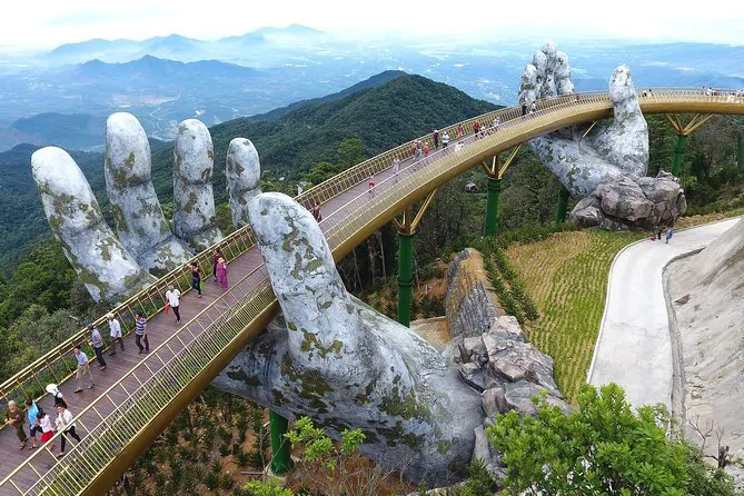
Twenty-five kilometers west, Ba Na Hills rises to 1,487 m above sea level — high enough to have its own French colonial hill station, now reimagined as a resort and amusement park. The Golden Bridge (Cầu Vàng) — 150 m of gilded walkway supported by two giant stone hands emerging from the mountainside — is the single most photographed travel attraction in Vietnam right now. The image is extraordinary in person. The cable car ascent (5.8 km, a former world record) passes through cloud forest. Pack a jacket regardless of the season; the summit is often 15°C cooler than the city below.
Zone 7 travel time from city center: 45–60 min by car · Cable car ride: 20 min.
Zone 8 — Greater Da Nang: Hội An & UNESCO Heritage Area
Here is what changed on July 1, 2025, and why every tourist map printed before that date is now incomplete: Hội An Ancient Town (15.8801°N, 108.3380°E) is no longer a day trip to another province. It is Da Nang.
The 15th–19th century trading port — with Japanese covered bridge, Chinese assembly halls, French colonial shophouses and Vietnamese tube homes all layered into one glowing UNESCO World Heritage streetscape — sits 30 km south of the city center. Visit on the Full Moon Lantern Festival (every lunar 14th): electric lights off across the old town, 1,000 paper lanterns on the Thu Bon River, and the kind of quiet that makes you forget there is a modern city an hour behind you.
Mỹ Sơn Sanctuary (15.7637°N, 108.1199°E), 70 km from Da Nang center, is the second UNESCO World Heritage Site now within city limits. The 4th–13th century Hindu Cham temples rise from a jungle valley, half-ruined by war and time, still extraordinary. Visit at opening (7:30 AM) before the heat and before the tour groups arrive.
Cù Lao Chàm Islands — a UNESCO Biosphere Reserve at 15.9500°N, 108.5200°E — is accessible by speedboat from Hội An in 20 minutes. The coral reefs around the islands are among the healthiest in the South China Sea. Snorkeling and diving tours depart daily from Cửa Đại pier.
Cam Thanh Coconut Village offers the iconic basket boat ride through a dense nipa palm forest — genuinely fun, genuinely local, and 3 km from Hội An center. Trà Quế Vegetable Village (16th-century organic herb farm) runs cooking classes that are worth every hour.
Zone 8 travel time from Da Nang center: Hội An — 45 min · Mỹ Sơn — 90 min · Cù Lao Chàm — 45 min by car + 20 min by speedboat.
Local Food: What to Eat and Where
The Da Nang Tourist Map 2026 marks eight regional dishes. Here they are in order of importance for a first visit — with the honest local opinion on each.

Practical Travel Notes
Airport: Da Nang International Airport (DAD) — 4 km from city center. Use Grab app: approximately ₫50,000–80,000 VND to any beach hotel. Journey time: 10–15 min outside rush hour.
To Hội An: 45 min by Grab car (~₫200,000) or yellow bus #1 (₫30,000, departs Hội An bus station hourly).
Getting around Da Nang: Grab motorbike for short trips (₫15,000–40,000). Rent a motorbike yourself for full-day exploration (₫100,000–150,000/day from most hotels). Bicycles available near the beach.
Train: Da Nang Railway Station connects to Hue (2.5 hrs, from ₫70,000), Hanoi (17 hrs) and Ho Chi Minh City (17 hrs). The Da Nang–Hue coastal route — passing through the Hai Van tunnel — is one of the most scenic rail journeys in Southeast Asia.
Best time to visit: March–August (dry season, 28–34°C, calm seas). October–December brings heavy rain and typhoon risk. January–February is cool and overcast but crowd-free.
Currency: Vietnamese Dong (VND). ATMs widely available. USD accepted at most hotels. Markets and street food: cash only.
E-visa: 90-day single-entry or multiple-entry e-visa available online at evisa.xuatnhapcanh.gov.vn. Apply at least 3 business days before travel.
Emergency: Police 113 · Ambulance 115 · Fire 114
Hospital: Da Nang Hospital C — 122 Hai Phong Street (central location, English-speaking staff on duty).
FAQ: Common Questions About Da Nang
What are the best things to do in Da Nang in 2026? The top things to do in Da Nang include: watching the Dragon Bridge fire show (free, Saturday and Sunday 9 PM), visiting the Museum of Cham Sculpture, swimming at My Khe Beach, hiking Son Tra Peninsula for Lady Buddha and douc langur monkeys, and taking a full-day trip to Hội An Ancient Town — now part of Greater Da Nang since July 2025.
Is Hội An part of Da Nang in 2026? Yes. Since July 1, 2025 (Resolution 202/2025/QH15), Hội An, Mỹ Sơn Sanctuary and the surrounding Quảng Nam area officially merged into Da Nang. Both UNESCO World Heritage Sites are now within Da Nang city limits — no longer a separate province trip.
How many days do I need in Da Nang? A minimum of 3 full days covers the essential attractions: Day 1 for the city center and river bridges, Day 2 for Son Tra Peninsula and Marble Mountains, Day 3 for Hội An Ancient Town or Mỹ Sơn Sanctuary. Five days allows a comfortable pace with Ba Na Hills and Cù Lao Chàm Islands added.
What is the best time to visit Da Nang? March to August is the ideal travel window — dry, sunny, 28–34°C, with calm seas perfect for beach and island activities. Avoid October to December when the region experiences its heaviest rainfall and occasional typhoon activity.
How do I get from Da Nang to Hội An? By car or Grab app: approximately 45 minutes, ₫180,000–220,000 VND. By local bus: yellow bus #1 from Hội An bus station, ₫30,000, approximately 1.5 hours. By motorbike: 30–40 minutes via the coastal road (scenic and recommended).
Is the Da Nang Tourist Map 2026 GPS accurate? Yes. All 52 attractions are plotted with verified GPS coordinates cross-referenced against satellite imagery and physical ground visits. The map reflects the post-merger Greater Da Nang boundaries, including Hội An (15.8801°N, 108.3380°E) and Mỹ Sơn (15.7637°N, 108.1199°E) as official Da Nang attractions.
What is the Dragon Bridge fire show schedule? The Dragon Bridge (Cầu Rồng) breathes real fire and sprays water every Saturday and Sunday at 9:00 PM exactly. The show lasts approximately 15 minutes. Best viewing: Bach Dang Street on the west bank. Arrive by 8:30 PM for a front-row position. Entry is free.
Why This Map Exists
I have given directions to confused tourists on Vo Nguyen Giap Street more times than I can count. Watched them photograph the wrong bridge. Seen them spend a morning at Con Market when they meant Han Market, 1.5 km away. Watched visitors skip the Museum of Cham Sculpture — the single most important cultural site in the city — because no one put it clearly on the map.
The Da Nang Tourist Map 2026 is the map I wish I could have handed each of them: 52 verified attractions, accurate GPS coordinates, honest travel times between zones, the food you should not leave without eating, and the frank local knowledge that turns a fine trip into a memorable one.
Da Nang is not the same city it was a year ago. It is larger, richer in history, and — if you use the right map — easier to love.