Tham Ma Slope: The Breathtaking Curves of Ha Giang, Vietnam
Located in the stunning Ha Giang province, Tham Ma Slope is a thrilling destination that captures the hearts of adventurous travelers. Known for its dramatic curves and steep inclines, this winding road offers unparalleled views of lush mountains and deep valleys. Tham Ma Slope is a must-visit on your Vietnam Discovery Travel journey, offering both natural beauty and cultural exploration.

1. Overview of Tham Ma Slope
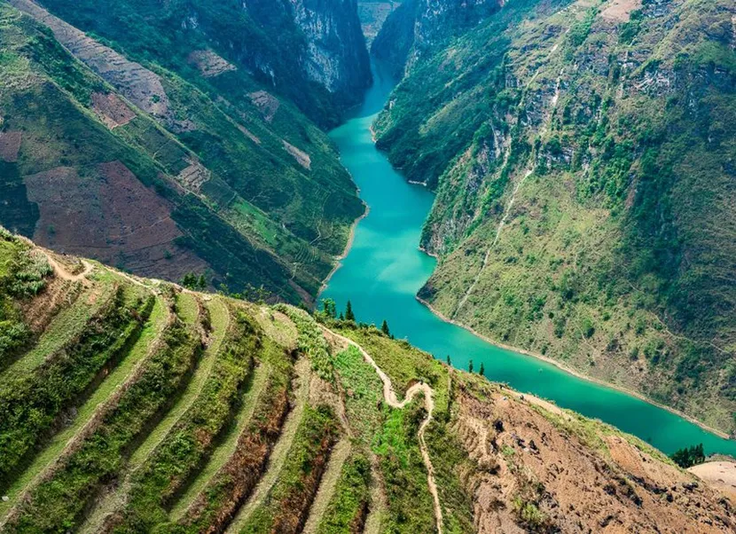
Tham Ma Slope, located in Ha Giang province, is a legendary stop on the well-known Highway 4C, often referred to as the “Happiness Road.” This iconic road connects Ha Giang to the breathtaking Dong Van Karst Plateau, a UNESCO Global Geopark. The slope is characterized by its 9 sharp curves, resembling a coiled snake nestled among towering mountains. Often covered in mist, Tham Ma Slope offers a dreamy yet challenging experience for those brave enough to tackle its rugged twists. Whether you’re an adventure seeker on a motorbike or simply exploring northern Vietnam’s landscape, Tham Ma will leave a lasting impression.
Historically, this slope has been a vital trade route for locals, particularly the Hmong ethnic group, who use it to transport goods. Its name, “Tham Ma,” loosely translates to “horse-testing slope,” a reflection of the area’s challenging nature where the strength and endurance of horses and their riders were once tested.

2. How to Get to Tham Ma Slope
Directions from Ha Giang City
The journey to Tham Ma Slope begins in Ha Giang city, approximately 51.7 kilometers (32.1 miles) away. To reach the slope, head northwest on Highway 4C towards Dong Van. The drive takes about 1.5 to 2 hours, depending on traffic and weather conditions. Along the way, you’ll pass through winding roads, with numerous spots to stop for photos and short hikes.
Best Routes for Travelers
For those coming from Hanoi, the best option is to first travel to Ha Giang city, either by bus or motorbike. The distance from Hanoi to Ha Giang is about 300 kilometers, which takes around 6 to 7 hours by car. Alternatively, you can book a guided tour with Vietnam Discovery Travel, which includes transportation and expert guides who can help you navigate the sometimes tricky roads.
3. The Ride: What to Expect on Tham Ma Slope
Riding Tips for Beginners and Experts
Riders should approach Tham Ma with caution, especially if they are not familiar with driving on mountain roads. The curves are tight, the slope is steep, and fog often blankets the area, making visibility difficult. However, even amateur scooter riders can enjoy the experience if they proceed slowly and pay close attention to the road. For safer navigation, ensure that your vehicle’s front lights and horns are in good working condition. These will be your best tools when visibility is low.
For expert riders, Tham Ma Slope is a dream come true. The sharp curves, combined with the mesmerizing scenery, make it one of the most exciting roads in Vietnam. Keep in mind, however, that the road can be slippery during the rainy season, so proper tires and protective gear are essential.
Safety Precautions and Gear Recommendations
- Helmet: Always wear a high-quality helmet.
- Lights: Good front lights are essential, especially if you’re riding early in the morning or late in the evening.
- Horns: Fog can reduce visibility, so a working horn is crucial for signaling to other riders.
- Proper Clothing: Wear durable, weather-appropriate clothing, as the temperature can drop significantly on the slope.
4. Best Time to Visit Tham Ma Slope
Seasonal Highlights
Tham Ma Slope can be visited year-round, but each season offers a unique perspective on the landscape.
- Spring (March to May): The slope is covered in lush green foliage, making it a prime time for photography.
- Summer (June to August): While the temperature is warmer, occasional rain can make the road slippery.
- Autumn (September to November): Clear skies and cool weather make autumn the ideal time for a ride, with colorful trees and perfect visibility.
- Winter (December to February): Winter brings a blanket of fog and colder temperatures, giving the slope a mysterious, otherworldly feel.
What Weather to Expect
On sunny days, Tham Ma Slope offers breathtaking panoramic views of the valley below. However, cloudy or foggy days give the slope an almost magical atmosphere, where the road seems to disappear into the mist. While the slope is navigable year-round, extra care should be taken during the rainy season due to the risk of landslides and slippery surfaces.
5. Photography and Drone Shots: Capturing Tham Ma’s Beauty
Best Spots for Photos
To truly capture the beauty of Tham Ma, head to one of the many viewing points along Highway 4C. The best views can be found slightly above the slope, where you can see the road’s winding path, stretching into the distance like a coiled serpent.
Flycam and Photography Tips
If you’re bringing a drone or “flycam,” make sure to use it on clear days for the best aerial shots. The full view from above shows the intricate curves of the road, along with the surrounding mountains and valleys. For those without a drone, traditional cameras or smartphones can still capture stunning shots, especially when the mist begins to rise, adding a sense of mystery to your photos.
6. Exploring the Surroundings
Local Culture and Children of the Mountains
While riding along Tham Ma, you’ll likely encounter local Hmong children. They are often seen playing by the roadside or offering small items for sale. Engaging with these children and capturing their smiling faces in your photos adds a unique, human touch to your journey. Many travelers appreciate this interaction as it offers a glimpse into the life of the mountain communities that thrive in this remote area.
Nearby Attractions to Include in Your Journey
- Dong Van Plateau: After conquering Tham Ma, continue your adventure to Dong Van Karst Plateau. This UNESCO-recognized geopark features incredible limestone formations and ancient fossils.
- Lung Cu Flag Tower: Located just a short drive from Dong Van, Lung Cu Flag Tower is the northernmost point of Vietnam and offers panoramic views of the surrounding landscape.
7. Essential Travel Tips
- Entrance Fees: Tham Ma Slope does not require any entrance fees, making it a perfect stop for budget-conscious travelers.
- Operating Hours: While you can technically visit Tham Ma at any time, daytime visits are recommended for safety and visibility.
- What to Pack: Bring plenty of water, snacks, and a fully charged phone for navigation. If you’re riding a motorbike, ensure you have a raincoat, as the weather can change rapidly.
8. Conclusion
Discover the majestic Tham Ma Slope with Vietnam Discovery Tours, offering safe and thrilling journeys through the winding roads of Ha Giang. Whether you’re an experienced rider or a photography enthusiast, this destination will captivate your adventurous spirit. For inquiries or bookings, contact us via WhatsApp to start planning your unforgettable experience in northern Vietnam.